Defining Land Erosion in the United States
In many parts of the country, land erosion significantly alters water flow and agricultural productivity. Topsoil can slip away from fields, then move into rivers, lakes, or coastal zones. This movement releases particles that may carry risky substances, posing hazards to local communities. It weakens riverbanks and disrupts wildlife habitats.
Preserving healthy soil requires understanding the triggers behind these changes. Protective vegetation breaks down when roots are exposed, leaving fragile topsoil vulnerable to harsh weather conditions.
Ecosystem Vulnerabilities
Eroded landscapes lose plant cover, allowing extra sediment to wash into nearby waterways. Fewer roots hold the earth together, so loose materials move more freely. Fertilizer residue or chemical runoff can mix with waterways, harming aquatic life and jeopardizing drinking water sources.
Common Causes of Soil Displacement
Farmland expansions and poorly managed construction sites often drive soil displacement by clearing away natural barriers. Deforestation strips protective tree roots, and stormwater accumulates on bare ground, washing particles downstream. This pattern appears in both rural fields and urban developments, adding unwanted sediment to streams and lakes.
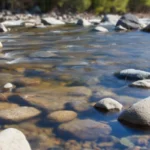
The Science Behind Sediment Runoff
Rainfall sets off a chain reaction, carrying soil and silt into streams. The speed of water determines how far particles travel. Steep terrain makes the flow even stronger. This pattern is what defines sediment runoff on plains and hillsides.
As sediment runoff grows, it reduces oxygen in water, making it cloudy. Fish struggle with clogged gills, and plants find it hard to make energy. These problems ripple through entire food webs.
Scientists closely watch sediment runoff as a key part of pollution. By understanding what causes it, they develop programs to protect habitats and keep water clean.
- Increased turbidity limits photosynthesis
- Rapid flow extends particle travel distance
- High silt content reduces oxygen circulation
Factor | Impact on Water Quality |
Land Slope | Steeper inclines drive more erosion |
Soil Composition | Fine-grained particles remain suspended longer |
Velocity | Faster currents disperse sediments more widely |
Recognizing Pollutants Associated with Land Erosion
Runoff from shifting soil can introduce a range of contaminants into streams and rivers. When exposed farmland or disturbed land begins to erode, it loosens particles that may carry toxic materials. This movement contributes to nonpoint source pollution, as the harmful agents do not come from a single, easily tracked spot.
Some pollutants clog waterways, reduce water quality, or endanger fish and wildlife. Silt can build up and block sunlight, leading to lower oxygen levels. Fertilizers from fields may heighten algae growth that threatens aquatic balance. Certain heavy metals also bind to sediments, causing health hazards for those who rely on treated water.
Chemical, Physical, and Biological Elements
Eroded areas often release several categories of pollutants. Chemical substances include pesticides and industrial residues. Physical particles, such as debris, cause muddiness that chokes aquatic habitats. Biological waste, including bacteria from animal manure, can spread disease through drinking water sources. These combined factors underscore the broader challenge of nonpoint source pollution across diverse landscapes in the United States.
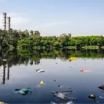
Water Pollution: The Direct Link to Land Erosion
Eroded soil carries nutrients and debris into nearby waterways. Wind and rainfall dislodge particles that enter streams and rivers, creating murky conditions. This process disrupts normal life cycles in aquatic ecosystems and affects recreational uses for local communities.
Sunlight penetration weakens when sediment clouds the water, lowering oxygen levels and harming diverse species. Farmers and property managers observe changes in water clarity and notice declines in fish numbers when erosion becomes widespread.
How Sediment Affects Water Quality
Particles traveling through currents act as carriers for excess nutrients. Algal blooms can form when phosphorus and nitrogen spike. Large blooms deplete oxygen, leading to fish die-offs that threaten aquatic ecosystems. Elevated turbidity also complicates filtration processes for drinking water systems.
Real-World Examples in Rural Areas
Large tracts of farmland lacking erosion control let topsoil flow into streams. Failing septic systems add more waste to the mix, triggering severe pollution issues. Local businesses that rely on fishing or nature tourism face economic setbacks tied to cloudy waters and declining fish populations.
Key Factor | Impact on Water | Outcome for Aquatic Life |
Excess Nutrients | Increased Algal Bloom Risk | Oxygen Depletion |
Poor Soil Management | Heavy Sediment Loads | Habitat Disruption |
Unprotected Streams | Contaminant Influx | Population Declines |
Case Study: Agricultural Hotspots in the Midwest
Farms in Iowa and Illinois are among the most productive in the country. High-yield systems are common here, but they often lead to fertilizer runoff. This runoff carries nutrient-rich sediment into nearby waterways, causing algae blooms. These blooms disrupt fish habitats and lower oxygen levels.
Erosion control is essential for maintaining productivity while protecting the environment. Large-scale tilling boosts harvests but increases soil displacement during heavy rains. Water samples from feeder streams show high nitrogen levels, indicating a need for better practices.
Farmers are now adopting changes to their fields and adding cover crops. These actions protect the soil surface and keep nutrients in place. Below is an overview of some effective solutions:
Farming Practice | Key Benefit |
Reduced Tillage | Less soil displacement, improved plant residue retention |
Cover Crops | Enhanced soil structure, stable nutrient uptake |
Buffer Strips | Lower sediment flow, healthier river zones |
Impact on Aquatic Ecosystems and Fisheries
Heavy sediment loads and contaminated runoff pose significant threats to the delicate life cycles in rivers and coastal bays. Fine particles adhere to spawning grounds, reducing oxygen levels and making it challenging for young fish to thrive. Various factors, including large dams and barriers, disrupt migration paths, exacerbating the fisheries impact.
Habitat Destruction
In the United States, over 75,000 dams, combined with millions of smaller barriers, disrupt natural flows across hundreds of thousands of river miles. Fine sediment clogs gravel beds, fills in hiding spots, and alters water temperatures by making wide channels shallower. This undermines both food sources and protective cover, leaving fish populations vulnerable.
Consequences for Local Communities
Declining fish stocks affect recreational outings and cut into livelihoods that depend on healthy waterways. Fishing towns experience decreased tourism, while commercial operations face shrinking harvests. The costs for restoring lost habitats can be high, placing a strain on state and municipal budgets. These changes spark challenges for everyone relying on stable aquatic systems for income and sustenance.
Analyzing Erosion Patterns in Coastal Regions
Waves, currents, and storm surges significantly alter shorelines across the United States, leading to notable land loss in some states. Human activities like construction and dredging accelerate this erosion, changing how sediments settle on beaches. In some areas, the coastline retreats by over two meters annually, posing increased risks to waterfront communities.
Coastal regions depend on balanced sediment movement for their stability. Yet, human interventions disrupt this balance, damaging protective wetlands. The lack of sustainable farming near shorelines can increase sediment runoff, exacerbating erosion and disrupting habitats. Wave energy intensifies these issues, with storm seasons being the most challenging for protective barriers.
State | Approx. Annual Erosion | Key Contributing Factor |
South Carolina | 2 meters | Shoreline development |
Louisiana | 2+ meters | Dredging and rising seas |
Virginia | 2 meters | Disrupted sediment transport |
Texas | 2+ meters | Harsh wave action |
Comparing Riverine Pollution Sources
In the United States, runoff patterns differ due to local geography and land use. Geological changes lead to sediment loss, while development projects increase particle volume in rivers. This mix necessitates a focus on protecting water quality through effective strategies.
Communities analyze erosion rates to differentiate natural flows from those influenced by human activities. Public policy often guides efforts to minimize construction impacts and limit deforestation near sensitive watersheds.
Natural vs. Human-Induced Erosion
Weathering and tectonic movements cause sediment release. Intensive agriculture accelerates this process by removing vegetation over large areas. Deforestation and unregulated land use increase river loads, threatening downstream ecosystems.
- Geological Factors: Regular breakdown of rock and soil over centuries
- Human-Related Causes: Overgrazing, urban expansion, and extensive farm tillage
Public policy plays a critical role in balancing economic growth with environmental protection. Communities work with agencies like the U.S. Environmental Protection Agency to establish fair standards for watershed protection. Access to scientific research informs these regulations.
Common Erosion Drivers | Mitigation Steps |
Land Clearing | Reforestation and controlled development zones |
Agricultural Expansion | Soil conservation and minimal tillage practices |
Urban Growth | Stormwater management and protective building codes |
Role of Public Policy in Erosion Control
Legislation plays a key role in protecting local waters from excessive sediment. The Clean Water Act sets strict discharge limits. It also encourages upgrades to wastewater treatment plants to safeguard streams and lakes. State and federal agencies provide financial incentives to farmers and landowners to adopt safe land practices.
This approach helps stabilize slopes and reduces the erosion of topsoil. Policymakers work with various stakeholders to tackle nutrient pollution and other runoff threats from unmanaged erosion. They support projects like vegetative buffers, rain gardens, and retention ponds through grants and cost-sharing programs.
Public agencies conduct inspections to ensure these projects meet high standards. This ensures rivers remain clean. These partnerships enhance accountability and protect vital habitats.
Community leaders are also learning new ways to manage fields and construction sites. This reduces nutrient pollution at its source. Policy actions guide these efforts, combining science-based regulations with targeted funding. This protects water quality for future generations.
Best Practices for Land Management
Responsible land management is key to maintaining healthy soils and protecting vital water sources. Producers who keep at least 30% of the soil covered after planting face less soil disturbance. This method reduces erosion and limits the entry of fertilizers and pesticides into water tables.
Soil Conservation Techniques
No-till farming preserves the soil surface, maintaining organic matter and preventing runoff. Cover cropping, planting protective varieties between main crops, also sustains soil structure. Mulching and contour buffer strips further stabilize fields, slowing water flow and preventing sediment buildup. These practices lower the risk of groundwater contamination and promote steady yields.
Sustainable Farming Approaches
Conservation tillage minimizes soil disruption, leading to better infiltration and healthier root systems. Farmers often rotate crops to break pest cycles and improve soil fertility. Planting permanent vegetation around fields acts as a natural barrier, filtering excess nutrients before they reach aquifers. Such measures guard against groundwater contamination while supporting community water needs.
Real Examples of Conservation Efforts
Projects have tackled erosion’s environmental toll by establishing buffers, restoring wetlands, and adopting precision agriculture. The Nature Conservancy in the Mississippi River Basin spearheaded a massive wetland restoration. This effort significantly cut sediment runoff into key tributaries.
Each restored wetland area enhanced water clarity, fostered healthier fish habitats, and bolstered local flood management. In the Pacific Northwest, collaborations with farmers promoted cover crops and no-till farming. This strategy boosted crop yields while safeguarding soil health.
Restored wetlands in the Chesapeake Bay region also saw a rise in marine life oxygen levels. These initiatives highlight the environmental benefits of community-driven solutions. By integrating scientific knowledge with local insights, the U.S. has adopted cost-effective methods to reduce water pollution and combat erosion.
Challenges in Monitoring Sediment Levels
Measuring sediment loads across diverse landscapes can strain local resources. Dedicated sediment monitoring often requires additional coordination and steady funding for specialized equipment. Teams in charge of field studies navigate remote sites, which adds complexity to their schedules.
Reliable sediment monitoring depends on accurate observations repeated over time. The U.S. Geological Survey and state agencies coordinate efforts, yet funding remains unpredictable. Data gaps appear when volunteers lack modern tools or when sensors fail to record sudden fluctuations.
Data Collection Methods
Water testing with samplers and gauging stations plays a key role in tracking contaminants. Drones and satellite imagery track turbidity shifts that might signal harm to aquatic habitats. Local communities contribute field notes that complement official reports.
Technology Gaps and Limitations
Advanced devices streamline tasks by providing real-time readings. They become less effective when connection issues or hardware costs hinder widespread adoption. Underserved regions often struggle to maintain consistent coverage across vast watershed areas.
Cutting-Edge Solutions for Prevention
Communities are embracing new engineering strategies to fortify shorelines and safeguard water quality. These methods combine cutting-edge technology with the power of nature. They aim to reduce runoff and enhance habitat health. Advanced modeling identifies high-risk areas, enabling experts to implement interventions before erosion worsens.
Innovators are constructing banks with structures filled with vegetation and engineered wetlands. These features slow down sediment flow and protect vulnerable zones. Research from NOAA and the US Army Corps of Engineers supports these strategies. They balance safety, ecology, and cost-effectiveness.
- Living shorelines that absorb wave energy
- Vegetative buffers for decreased sediment buildup
- Predictive tools for mapping erosion hot spots
Method | Key Benefit | Lead Agency |
Engineered Wetlands | Filters runoff and stabilizes soil | US Army Corps of Engineers |
Living Shorelines | Reduces coastal erosion and nurtures native species | NOAA |
Predictive Models | Forecasts erosion trends | Universities & Labs |
Collaborations that Drive Environmental Impact
Public agencies and nonprofit groups often join forces to protect sensitive habitats and restore watersheds. This partnership boosts awareness about land erosion and encourages community involvement. Local officials introduce funding programs, while research teams enhance field data, driving solutions to slow soil displacement.
Many groups focus on water quality standards when developing action plans. For example, the U.S. Environmental Protection Agency funds grants aimed at reducing runoff. These grants support the development of modern infrastructure that filters sediment and chemicals before they reach rivers and lakes. Nonprofits also organize training sessions to demonstrate the practicality and durability of preventive measures.
Partnerships Between Governments and NGOs
State departments and organizations like The Nature Conservancy work together on pilot programs to combat topsoil loss. They use local expertise to guide erosion control efforts, uniting landowners, scientists, and citizens. This collaboration improves water quality standards and promotes sustainable resource management, protecting aquatic life for generations to come.
Looking Ahead to Sustainable Waterways
Researchers and policymakers in the United States envision a future where streams, rivers, and coasts are preserved. Erosion-induced water pollution is a major concern, but advancements in monitoring sediment flows offer hope. Field studies and data platforms are now tracking changes in flood risk and identifying problem areas for immediate action.
A shared vision for the future of water is taking shape, driven by public and private sector collaboration. Strengthened regulatory actions and local engagement are key to reducing water pollution. The balance between farmland, forests, and urban spaces is essential for preserving aquatic life and safeguarding vital resources for communities.
Innovation brings optimism for long-term stability. Drone technology, green infrastructure, and precision farming are being explored to combat erosion before it harms waterways. Communities demand better guidelines and more research investments. By aligning science, policy, and everyday actions, we can protect habitats, fisheries, and public health.
Stricter oversight of nutrient runoff and sustainable land use are critical to protect lakes and coastal zones for future generations. Environmental agencies, academic institutions, and local groups must collaborate to prevent erosion-related threats. Long-term efforts and robust policies are essential for achieving cleaner, healthier waters.
FAQ
How does land erosion lead to nonpoint source pollution in American waterways?
Topsoil loss due to heavy rains, deforestation, or stormwater runoff carries contaminants into streams and rivers. These contaminants include fertilizers, pesticides, and heavy metals. This type of pollution, known as nonpoint source pollution, comes from large, unconfined areas, not specific outlets.
Why is sediment considered a primary pollutant in many lakes and rivers?
Sediment particles can smother fish habitats and block sunlight, hindering plant growth. They also transport harmful substances. As a result, sediment is a major water pollutant, affecting water quality and ecosystem health.
What role do agricultural practices play in accelerating soil erosion?
Improper tilling, overuse of fertilizers, and lack of vegetative buffers can displace topsoil. This leads to increased sediment runoff. Heavy rains can then wash away the loosened soil, carrying fertilizers and pesticides into water bodies.
Are there effective conservation techniques to reduce land erosion?
Yes. Methods like no-till farming, cover cropping, and precision agriculture help keep topsoil stable. Vegetative buffers near waterways slow water flow, trapping sediment before it reaches rivers and lakes.
How do coastal regions deal with erosion differently from inland areas?
Coastal erosion is affected by wave action, tidal currents, and coastal development. Communities use living shorelines or engineered wetlands to stabilize these areas. These methods also filter out contaminants and preserve marine habitats.
What is the link between nutrient overload and algal blooms?
Nutrient overload from eroded soil, enriched with fertilizers, can cause algal blooms. This condition, known as cultural eutrophication, depletes oxygen levels. It harms fish and other aquatic life.
How do public policies address erosion-related water pollution?
The Clean Water Act sets guidelines and funds erosion control measures. Incentive programs encourage landowners to adopt best management practices. This includes vegetative buffers and responsible fertilizer application to reduce sediment runoff.
Can community partnerships help reduce erosion impacts on water quality?
Yes. Joint efforts by federal agencies, local governments, and nonprofits can enhance erosion mitigation. By pooling resources, they implement projects like streambank restorations and wetland enhancements. This results in cleaner waterways and healthier ecosystems.
What challenges exist in monitoring sediment levels in real time?
Monitoring sediment levels requires specialized equipment and frequent sampling. This is costly and labor-intensive. Emerging technologies measure turbidity and flow rates more efficiently. Yet, funding constraints and limited staffing hinder data collection.
Are there innovative tools to prevent excessive sediment from entering water bodies?
Yes. Techniques like engineered wetlands and advanced modeling predict high-risk erosion areas. This guides targeted solutions. Living shorelines, contour farming, and effective stormwater management structures also reduce soil transfer to rivers, lakes, and coastal zones.